UAV detection equipment

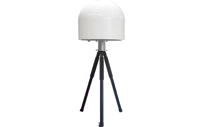
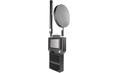
Radio Monitering Equipment
GWDEF-RM100
The radio monitoring equipment can achieve real-time search, detection and alarm for the data transmission and control signals of unmanned aerial vehicles (UAVs), and has the functions of parameter measurement, single-station direction finding, and rough distance measurement for the data transmission and control signals of UAVs. It also has the functions of pilot positioning and black and white list. Combined with the identification database, it can identify the model and manufacturer of the UAV. The equipment can also locate and continuously track the UAV, and display its position and flight path in real time on the electronic map.
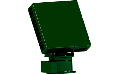
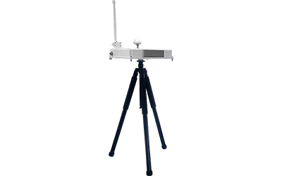
Radar detection equipment
GWDEF-RADAR1000
Radar equipment is a low-power detection radar developed for "low, slow, and small" targets, used for long-range detection and discovery of unmanned aerial vehicles in sensitive airspace,
Provide precise three-dimensional location information of the target, achieving 360 ° full coverage of the regulatory area.
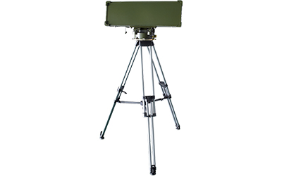
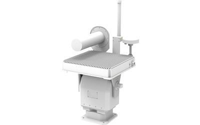
Low-altitude Surveillance Radar
GWDEF-RADAR1000
The Low Altitude Surveillance Radar can achieve precise detection and tracking of low and slow small targets such as drones, display and output multi-dimensional information such as target distance, azimuth, elevation, velocity, altitude, and intensity, and form a three-dimensional motion situation of low altitude targets.
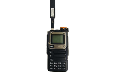
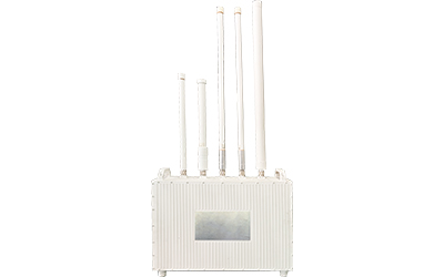
Individual UAV Detection and Early Warning Instrument
GWDEF-RM100
The device adopts self-developed low-power digital-analog hybrid receiver technology and advanced power management technology, featuring an external ultra-wide band antenna, capable of accurately detecting common civilian drones including quadcopters, fixed-wing drones, DIY drones, and racing drones, achieving precise audio, visual, and vibration alerts while maintaining an extremely low false alarm rate in complex electromagnetic environments. It boasts high sensitivity and low false alarm rates, is compact in size, and shielding well.
Individual Drone Detection and Early Warning Instrument
GWDEF-RM200
The Individual Drone Detection and Early Warning Instrument adopts self-developed low-power digital analog hybrid receiving technology and advanced power management technology. It uses high gain, low gain, and directional ultra wideband antennas, and can make sound and vibration alarms to common civilian unmanned aerial vehicles including quadcopters, fixed wings, DIY drones, racing drones, etc. while also achieving extremely low false alarm rates in complex electromagnetic wave environments.
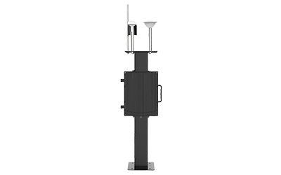
UAV identification equipment
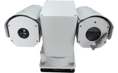
Dual Spectrum Infrared Night Vision T-type Gimbal
GWDEF-OE2000
The Dual Spectrum Infrared Night Vision T-type Gimbal Camera adopts a high-strength shock-absorbing alloy die-casting shell on the body, with overall three proof spray coating. It has the performance of heat insulation, high and cold temperature resistance, impact resistance, corrosion resistance, and wind and shock absorption. Built in high-definition of light & fog visible network camera and high-sensitivity thermal imaging detector, suitable for various close range target detection, tracking, it could realize 24 hours daily uninterrupted monitoring in condition of low light, severe haze weather and night.
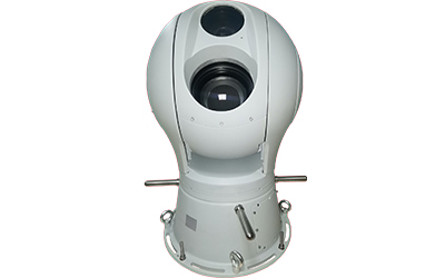
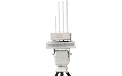
Ball Shaped Intelligent Tracking Servo Gimbal
GWDEF-OE3000
The Ball Shaped Intelligent Tracking Servo Gimbal adopts a fusion of high-definition visible light, infrared thermal imaging, laser night vision and other multispectral technologies, which can achieve all-day clear imaging, ultra long focus, long-distance target detection, full screen automatic search, discovery, locking and tracking.
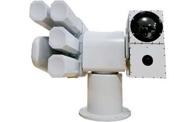
Integrated UAV Countermeasure System
GWDEF-RMRC1000
The Multi Spectral Thermal Imaging Detection, Recognition and Combat Integrated UAV Countermeasure System, integrating ultra long focal length light visible fog transparent high-definition network camera, long-range passive infrared thermal imaging detector, intelligent recognition module, servo heavy-duty gimbal and jammer combined, realizing multi spectral and multi-channel day night complementary imaging, and 24-hour day night monitoring in low light, severe weather, night and other conditions.
UAV Countermeasure equipment
Drone Detection and Countermeasure Equipment
GWDEF-RMCM1000
The Drone Detection and Countermeasure Equipment is an integrated device for detecting, striking, and countering drones. It has independent striking mode and automatic detection striking mode, and is easy to operate. The countermeasure equipment adopts narrowband interference technology and radio frequency suppression technology to cut off the connection between the drone and the remote control. After the drone is controlled, the image transmission channel is cut off, and it will not be able to transmit videos, aerial photos, or receive any instructions from the ground remote control, thus achieving the protection of key areas and preventing privacy leakage.
Active Defence Equipment Against UAV
Model:GWDEF-CM1000
The main method used is wireless ultra low power precise deception with a power of less than 10mW, continuously transmitting GPS coordinates within the protected range to shift in one direction (the offset per second can be set). When the drone receives GPS deviation, it will calibrate its attitude, which is manifested as continuously shifting in one direction, causing the "black flying" drone to receive the constantly shifting navigation signals and force it to leave the defense area.
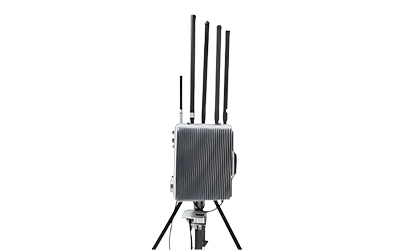
Omnidirectional Interference Equipment
Model:GWDEF-CM4000
The Omnidirectional Interference Equipment uses a combination of omnidirectional antennas to block and interfere with the reception and processing of image transmission, remote control, and navigation signals of unmanned aerial vehicles within a 360 ° range, achieving countermeasures such as forced return, forced landing, and departure, thus quickly and effectively disposing of suspicious unmanned aerial vehicles.
Directional and Omnidirectional Integrated Electromagnetic Interference Equipment
GWDEF-CM5000
Capable of conducting eight directional electromagnetic interference (north, south, west, east, northwest, southwest, southeast, northeast) on unmanned aerial vehicles; The system has two signal transmission modes: directional and omnidirectional; The device is capable of transmitting interference signals, while also interfering with the wireless control link, navigation link, and wireless image transmission signal of the drone; Capable of driving away and returning, and interfering with on-site emergency landing modes; Capable of frequency hopping interference; Capable of manually/automatically selecting the strike frequency band (linked through detection devices); Equipped with self checking function and abnormal reporting function;
Navigation Deception Device
GWDEF-ND2000
The Navigation Deception devices use simulated satellite navigation signals to perform location spoofing, speed spoofing, and time spoofing on drones. The device implements different deception strategies on the drone navigation terminal to achieve functions such as driving away, forced landing, and direction guidance for the drone.
Integrated Directional and Omnidirectional Navigation Deception Equipment
GWDEF-ND3000
Capable of performing eight heading deception (north, south, west, east, northwest, southwest, southeast, northeast) on unmanned aerial vehicles; The system has two signal transmission modes: directional and omnidirectional; Capable of performing heading deception, angle deception, and no fly zone emergency landing on unmanned aerial vehicle navigation signals; Capable of automatic/manual adjustment of signal output power; Capable of automatically locating the device's location through GPS; Capable of integrating radar, electro-optical and other equipment to achieve designated point emergency landing of unmanned aerial vehicles; Capable of intelligent device inspection and reporting the abnormal.
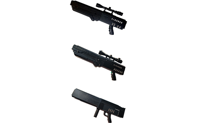
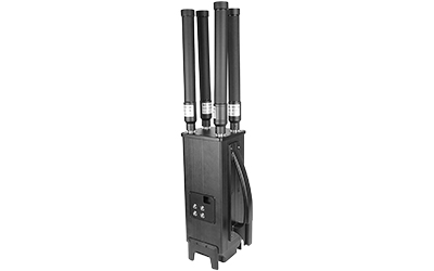
Portable UAV Countermeasure Gun
GWDEF-CM100
The Portable UAV Countermeasure Gun adopts ultra-high frequency broadband interference technology and radio frequency suppression technology to cut off the connection between the drone and the remote control, thereby forcing the drone to perform landing or return. And after being controlled, the drone has cut off the image transmission channel, and will not be able to transmit videos, aerial photos, or receive any instructions from ground remote controllers, thus achieving the goal of protecting key areas and preventing privacy from being leaked.
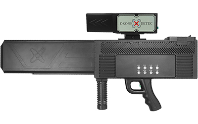
Portable Anti-drone Gun with Integrated Detection and Countermeasures
GWDEF-RMCM200
The Portable Anti-drone Gun with Integrated Detection and Countermeasures is a portable drone countermeasure device consisting of a countermeasure body and a detection body. It first alerts drones from a distance through detection then uses electronic warfare to emit high-power directed electromagnetic waves which can cut off the communication link, video transmission link, and navigation link of drones, forcing them to land on-site or return to the original flight path, thus ensuring airspace safety within approximately 2000-2500 meters.
Portable Drone Countermeasure Shield
GWDEF-CM400
The GWDEF-CM400 counter shield can effectively force a drone to land or return within a radius of about 2,000-2,500 meters, and people on the ground cannot operate the drone, nor can the drone transmit the detected images and videos to the ground.
Portable Drone Countermeasure Equipment
GWDEF-CM500
This device interferes with the drone's flight control system and signal transmission system to enable the drone to drive away or make an emergency landing, which can achieve a faster and more accurate strike effect and ensure the safety of the airspace in the area. The product is easy to use, convenient to carry, with an effective shielding distance of 2-3 kilometers (the shielding effect varies depending on the environment and drone model).
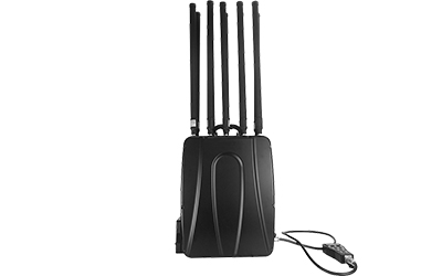
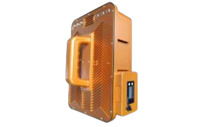
Pack-type Single Soldier UAV Countermeasure Device
GWDEF-CM600
The Pack-type Single Soldier UAV Countermeasure Device is a high-power omnidirectional backpack style unmanned aerial vehicle countermeasure device with built-in lithium batteries. It is easy to operate and can achieve single frequency control. The device adopts narrowband interference technology and radio frequency suppression technology to cut off the connection between the unmanned aerial vehicle and the remote control, thereby forcing the unmanned aerial vehicle to return. And after being controlled, the drone has cut off the image transmission channel, and will not be able to transmit videos, aerial photos, or receive any instructions from ground remote controllers, thus achieving the goal of protecting key areas and preventing privacy from being leaked.
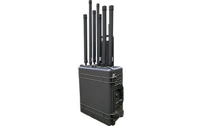
Portable Box Pulling Drone Countermeasure Equipment
GWDEF-CM800
This is a portable high-power drone countermeasure device with a suitcase design that is easy to move and carry, and convenient for multi destination conversion. It is designed with high-power omnidirectional coverage, covering a range of 1 kilometer. In use, it can create a 1-kilometer drone safety zone, providing protection for life safety and privacy keeping.
Control Platform
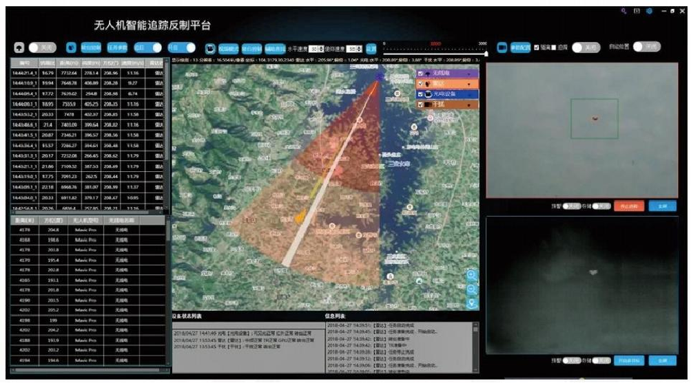
Cloud Control Platform
GWDEF-SCP3000
The unmanned aerial vehicle detection and countermeasure control system adopts advanced information management technology to complete central monitoring, command and dispatch, and statistics of past flights Row data, etc.